
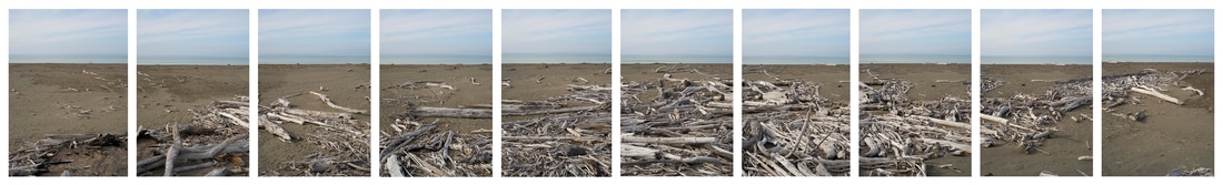
Rangitukia Hikoi 0-14 in Precarious Nature, COCA Christchurch 2016-17
Rangitukia Walk (a drawing) 2016 - Exhibited in Ata Te Tangata, at Pingyao Festival of Photography, China. 2016.
A hundred and twenty-five years ago, the Waiapu River was clean. Then native trees flanking the hinterland foothills and mountains were stripped bare from 1890-1920. Slash and burn deforestation caused widespread erosion. Now, land collapses and subsides into the river in each storm. In larger ‘weather events’ such as Cyclone Bola in 1988 many hundreds of trees were swept into the river. Their whitened trunks and branches lie exposed as the mouth of the river and along the beach to the south. A tribal saying ‘Haere kaua ki Waiapu, ki tatara ki mara ana’ speaks of people whose lives were under threat, fleeing to a place of refuge, a place of cover. While this is a metaphor, it is also indicative of the once-forested lands provide shelter. Now the hills are bare. The slow catastrophe of long term erosion is being addressed by the Waiapu River Accord (2014).
The Ngāti Porou iwi (tribe) of the East Cape, Aotearoa (New Zealand) region are moving towards a one- hundred-year revitalisation project along the ancestral Waiapu River. Part of a larger project, Rangitukia Beach (Walk Series – May 2016) pictures the beach just north of Waiapu ngutu awa (river mouth), overlaid with driftwood and the skeletal debris of trees. This is part of a larger history of colonial deforestation since 1890. These The ‘walk series’ images functions as drawings towards an intended tribal archive, to provide a baseline record of the riverine and coastal environment of the Waiapu River. The Ngāti Porou iwi (tribe) of the area are moving towards a one- hundred-year revitalisation project along the ancestral Waiapu River. This work intends to show whakapapa (discussed colloquially amongst Māori as ‘bones’) of the trees and their resting place.
The Ngāti Porou iwi (tribe) of the East Cape, Aotearoa (New Zealand) region are moving towards a one- hundred-year revitalisation project along the ancestral Waiapu River. Part of a larger project, Rangitukia Beach (Walk Series – May 2016) pictures the beach just north of Waiapu ngutu awa (river mouth), overlaid with driftwood and the skeletal debris of trees. This is part of a larger history of colonial deforestation since 1890. These The ‘walk series’ images functions as drawings towards an intended tribal archive, to provide a baseline record of the riverine and coastal environment of the Waiapu River. The Ngāti Porou iwi (tribe) of the area are moving towards a one- hundred-year revitalisation project along the ancestral Waiapu River. This work intends to show whakapapa (discussed colloquially amongst Māori as ‘bones’) of the trees and their resting place.